

Jakarta, ThedailyID — NASA has raised concerns over wildfires across Papua, where carbon emissions surged between September and October 2026. Fires in Papua New Guinea have released record amounts of carbon for this period, while emissions in Indonesia’s Papua region have exceeded 35 million metric tons.
In a report published on October 22, NASA linked the widespread fires to severe drought associated with a strong El Niño phenomenon. The dry conditions have left vegetation vulnerable to uncontrolled fires across the island.


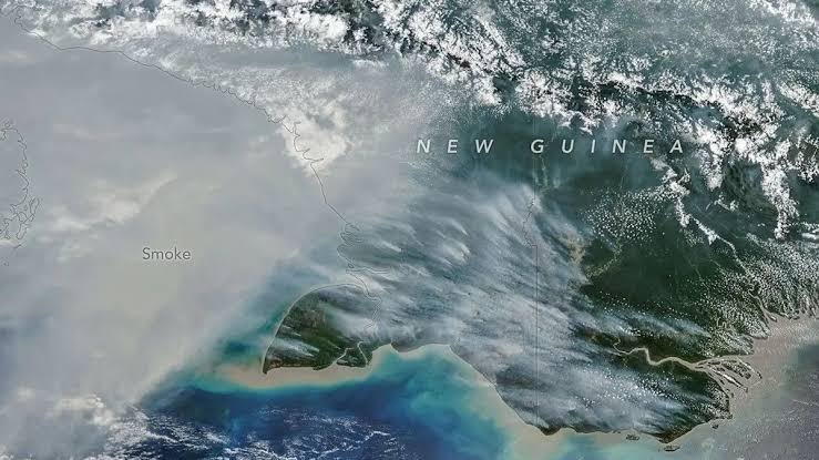
Thick smoke has covered parts of Papua New Guinea for weeks, worsening air pollution and disrupting flights. Some schools have also suspended classes because of the conditions.
On October 11, the NOAA-20 satellite captured thick smoke rising from southern Papua. Its Visible Infrared Imaging Radiometer Suite (VIIRS) instrument recorded the smoke plume.
Robert Field, a researcher at NASA’s Goddard Institute for Space Studies and Columbia University, explained how smoke behaves in the atmosphere. Some smoke rises to higher atmospheric layers, while rain can wash out particles when storm systems arrive.
However, much of the smoke stays close to the Earth’s surface and worsens air quality. “This is a terrible situation,” Field said on October 22.
Data from the Global Fire Emissions Database (GFED) showed that fires in Papua New Guinea had released nearly 32 million metric tons of carbon by October 17, 2026. This marked the highest recorded emissions for the same period in the database’s records.
Guido van der Werf, a fire scientist at Wageningen University & Research, said emissions had already surpassed the total for all of 2015. He added that 2026 could become Papua New Guinea’s highest-emission year on record, potentially exceeding 1997.
Meanwhile, fires in Indonesia’s Papua region had released more than 35 million metric tons of carbon. This ranked as the third-highest level on record, behind 2015 and 1997, when El Niño also contributed to severe fires.
GFED estimates vegetation fires and carbon emissions using satellite data, vegetation characteristics and other information. The database has tracked these patterns for nearly three decades.
NASA explained that El Niño has changed rainfall patterns, leaving ecosystems across Papua unusually dry. In southern Papua New Guinea, the Trans-Fly savanna and grassland region endured more than 90 consecutive days without rain.
Weather data also showed that some areas received only 5% to 10% of their normal rainfall since August. The prolonged drought has increased fire risks and contributed to crop failures, water shortages and school disruptions.
Researchers said many fires in Papua stem from human activities, including agricultural burning, pasture management, forest clearing and hunting. People may carry out these activities under controlled conditions, but dry vegetation allows flames to spread more easily.
Yang Chen, a researcher at the University of California, Irvine, said fire activity this year was much higher in Papua New Guinea and eastern Indonesia than in western regions. He specifically highlighted Indonesian Papua and Kalimantan, compared with Sumatra and other parts of western Indonesia.
NASA also highlighted land-use changes across Papua over the past two decades. In Indonesian Papua, forest clearing has supported oil palm plantations, pulpwood crops, small-scale agriculture, urban expansion and mining.
Data from Global Forest Watch showed that Papua lost approximately 27,000 hectares of primary forest in 2025. That figure nearly doubled the 2024 loss and marked the highest level since 2017.
Researchers expect fires to continue until heavy rain returns to southern Papua, usually around early November. The timing and intensity of rainfall will influence how quickly the drought eases and fire activity declines.